|
|
Satellites like GOES 6 and Landsat 7
look at the Earth. Special sensors,
like those aboard the Landsat 7
satellite, record data about the
amount of infrared light reflected
or emitted from the Earth's surface.
|
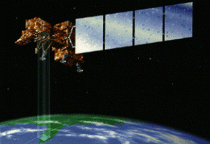
Landsat 7 |
Other satellites, like the Infrared
Astronomy Satellite (IRAS) look up into
space and measure the infrared light coming
from things like large clouds of dust and
gas, stars, and galaxies!
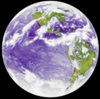
What does the Infrared show us?
| This
is an infrared image of the Earth
taken by the GOES 6 satellite in
1986. A scientist used temperatures
to determine which parts of the
image were from clouds and which
were land and sea. Based on these
temperature differences, he colored
each separately using 256 colors,
giving the image a realistic
appearance.
Why use the infrared to image the
Earth? While it is easier to
distinguish clouds from land in the
visible range, there is more detail
in the clouds in the infrared. This
is great for studying cloud
structure. For instance, note that
darker clouds are warmer, while
lighter clouds are cooler. Southeast
of the Galapagos, just west of the
coast of South America, there is a
place where you can distinctly see
multiple layers of clouds, with the
warmer clouds at lower altitudes,
closer to the ocean that's warming
them. |

Space Science and Engineering
Center,
University of Wisconsin-Madison,
Richard Kohrs, designer
|
We know, from looking at an infrared
image of a cat, that many things emit
infrared light. But many things also reflect
infrared light, particularly near infrared
light. Near infrared radiation is not
related to the temperature of the object
being photographed - unless the object is
very, very hot.
Infrared film 'sees' the object because
the Sun (or some other light source) shines
infrared light on it and it is reflected or
absorbed by the object. You could say that
this reflecting or absorbing of infrared
helps to determine the object's 'color' -
its color being a combination of red, green,
blue, and infrared!
continue to infrared waves
|